Over the next five to 10 years, wider roads, more traffic and additional commercial space are coming to The Acreage, wanted or otherwise in the semi-rural community. How to best manage the inevitable changes and maintain the area’s rural character is the only question, Indian Trail Improvement District officials said at a Wednesday, May 12 workshop meeting.
At the workshop meeting, the ITID Board of Supervisors heard a draft report from Kim DeLaney, director of strategic development and policy for the Treasure Coast Regional Planning Council, that may help guide some of those decisions.
“It’s just a question of the types of uses you want as a community,” DeLaney told the supervisors. “The idea is to make Indian Trail more resilient and sustainable.”
ITID President Betty Argue said that the plan itself does not make any changes.
“What we’re doing does not change any land use or zoning,” said Argue, noting that any such future changes will be up to the Palm Beach County Commission. “What this project does is allow us to identify possible problem areas and give feedback to the county about what we can live with.”
Funded by the Florida Department of Economic Opportunity’s Competitive Florida Partnership Program, the study focused mainly along state and county roadway corridors. Plans to widen several such corridors in The Acreage already have been approved by the county. ITID supervisors now must look for options within that framework.
DeLaney’s report suggests that ITID should push for appropriate landscaping and buffering for the widened roads, some bulging to five lanes, and that intersections that are natural for commercial use are developed in a way compatible with the area’s rural heritage.
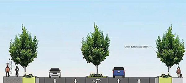
In a graphic displayed by DeLaney, she suggested a “rural parkway” concept for some of the expanded roads with a landscaped median, “bioswale” separating traffic from treelined sidewalks/bike paths and a horse trail.
“It’s not just a matter of simply five-laning roads,” DeLaney said. “It’s figuring out how they can work appropriately in our community.”
Meanwhile, shopping centers already are planned for the intersection of Northlake and Coconut boulevards. The land use study presented by DeLaney identified three other intersections that are likely locations for future shopping center development — Orange Blvd. and Seminole Pratt Whitney Road, Seminole Pratt and Persimmon Blvd. in Westlake, and 60th Street North west of 180th Avenue North.
While Westlake is not part of ITID, it is mostly surrounded by the district, and its commercial growth will impact traffic in the area.
The study also identifies five other areas that likely will be targeted for some development, and suggests that ITID press the county to allow only neighborhood-friendly projects, such as small restaurants, daycare centers, produce markets and limited office space. Those intersections are Northlake and Seminole Pratt, Seminole Pratt and Okeechobee Blvd., Orange and Coconut, Orange and 140th Avenue North, and Orange at 180th Avenue North.
“We need a few places like this to capture local business,” Supervisor Keith Jordano said of the neighborhood-friendly development concept, noting that one such intersection is near his home. “I’m not one to say, not in my backyard.”
“I think these could be great additions to our community,” Supervisor Joni Martin agreed.
More complex and perhaps more controversial is the idea put forth in the draft of introducing into limited areas, different types of housing, such as duplexes and townhouses built to look like single-family homes. Currently, all residential lots must be at least 1.15 acres.
“I like it, but longtime residents won’t,” Martin said. “It’s something we need, but it will be a hard sell. Too suburban, too close together.”
“My concern is that none of what we’re proposing is actually reducing traffic in the district,” Argue added.
While that may appear to be the case, DeLaney said that by bringing small businesses closer to neighborhoods, it would allow residents to walk, ride bikes or use golf carts to do errands they otherwise would have used a car to accomplish; or to drive shorter distances.
Saying that ITID is facing a “traffic tsunami” in the coming years, Argue recently urged residents to attend the workshop and participate in the visioning. However, there was no comment or input during the nearly two-hour session, although a handful watched the session online.
“It’s frustrating,” Argue said. “There is a level of complacency. We can’t force people to attend. But people need to get involved… This is not about my vision. The community needs to speak up and say what it wants.”
The final plan will be presented to the board in June.


