BY ANNE CHECKOSKY
Officials are worried that Palm Beach County’s good fortune over the last eight years — no hurricanes since Wilma in 2005 — may have lulled residents into complacency. And that could be dangerous, because experts are predicting an active hurricane season this year: 18 named storms, nine hurricanes and four intense hurricanes.
“We’re concerned,” Assistant County Administrator Vince Bonvento said.
But those charged with protecting the area during storms have been busy in recent weeks holding disaster drills and training sessions, and in one case, setting up a ham radio station.
This Friday, a ham radio station at the Loxahatchee Groves Water Control District will become active, District Administrator Stephen Yohe said. It’s just another way for the district to be able to communicate with residents should phone and cell service be interrupted or become intermittent during or after a storm, he said.
In addition, the LGWCD has reviewed and updated its hurricane preparation manual, made sure its generators are working and replaced batteries in radios and flashlights, Yohe said. He has also made sure his contacts are in place for disaster recovery, so that when it comes time for cleanup after a storm, the district will simply be able to call Bergeron Emergency Services and get started. Both the district and the Town of Loxahatchee Groves have contracts with the company, Yohe noted.
The Indian Trail Improvement District is keeping a close eye on water levels, as the beginning of hurricane season has been very wet, District Administrator Tanya Quickel said. Last Wednesday, May 29, 6.5 inches fell in the area, she noted. This week the rain has been heavy, with between 5 and 10 inches expected.
Quickel knows residents are sensitive about water levels after what happened last August when Tropical Storm Isaac dumped 15 inches of rain in the area. ITID staff is watching the canal levels, she said, adding that the ground is already saturated.
That’s one reason it’s important for residents to stay on top of yard landscaping. “Things just grow, grow, grow,” under these conditions when it’s moist and the temperatures are warm, she said.
Once a hurricane watch or warning is issued, residents are asked not to trim any vegetation. A big pile of yard debris sitting in a swale can block drains, or it might float away to end up clogging other drainage systems, Quickel said. Tree branches can become airborne during a storm and act like missiles. The time to take care of yard debris is now, she stressed.
Wellington’s Deputy Village Manager John Bonde said Isaac showed everybody that tropical storms can be just as devastating as hurricanes. “We had that 1 percent storm,” he said. “We know what that can cause as far as flooding.”
Being proactive in a situation like that is paramount. If village staff hadn’t gotten out five days in advance of Isaac to lower the lakes and canals in the area by 1.5 feet, water would have been in homes, Bonde said.
But he also noted that residents can’t and shouldn’t rely on government to help them after a storm. This is why planning before a storm is so critical, Bonde said. He advises having at least seven days’ worth of supplies and medications. Remember, during Hurricane Frances in 2004, power in the area was out for more than nine days, Bonde said.
He also encourages residents to talk to their neighbors and to relatives about what they’ll do during a storm. That way, everybody’s on the same page. “Don’t be an island,” Bonde said.
Bonvento agreed more. “Have a plan. Be prepared,” he said.
In particular, make prior arrangements for pets, seniors or anybody in need of specialty medical care. Not all shelters take pets and some aren’t able to care for those with special medical needs. Check ahead of time, Bonvento advised.
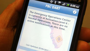
This year, the county has a new way to communicate with the public during and after storms: an interactive smart phone application. Called the disaster awareness and recovery tool or DART, it allows residents to communicate with county disaster teams to pinpoint damage. It works like this: residents can click on a photo of a house with minor, moderate or heavy damage and transmit that to the Emergency Operations Center. Or, they can simply take a photo of their damaged property and send that to EOC, Bonvento said.
The GPS on the phone will allow officials to identify that location. Officials can then download the information and plot it to identify damage trends. In addition, residents can use DART to find lists of gas stations or supermarkets that have generators, get updates on storms or monitor shelter openings.
“It’s going to give us a much quicker assessment,” he said.
Also new at the EOC this year is a special monitoring room for Facebook and Twitter feeds, Bonvento added. The interactive communication will allow officials to know what’s going on in its communities and be able to get important information out to residents in a timely manner, he said.
For more information on preparing for a hurricane, visit www.pbcgov.com and click on its hurricane preparedness tab.
ABOVE: The new Palm Beach County DART app.


